420m@80% range 5mm@30m accuracy high frequency mobile LiDAR system
HiScan-R with 30M pixcels panoramic camera
HiScan-R lightweight 3D mobile LiDAR system is a Riegl LiDAR based
mobile surveying and mapping equipment launched by Wuhan Hi-Cloud
Technology Co., Ltd.. It integrates laser scanning equipment (LS),
satellite positioning module (GNSS), inertial navigation unit
(IMU), wheel encoders, panoramic cameras, assembly control module
and high-performance board computer, etc..
It can collect point cloud data and panoramic images in real time.
It is convenient to install in cars, beach buggies, ships or other
mobile carriers. The production and processing of vector map data,
street view data and geographic data can be easily completed during
the movement of the carriers. It is widely used in topographic
survey, urban municipal component survey, urban garden survey,
traffic survey and design, traffic information survey, street view
map service, digital city, waterway and island survey and other
fields.
Main parameters of HiScan-R mobile LiDAR system
| Items | Hiscan-R |
| Number of Scanners | 1 |
| Range Measurement | 420m@80% reflectivity |
| Laser Frequency | Max. 1,000,000points/s |
| Range Accuracy | 5mm@30m |
| Angular Resolution | 0.0088° |
| Panoramic Camera | Ladybug |
| Panoramic Camera Resolution | 30M pixels |
| Accuracy | 5cm@100m |
| Scan Speed | 10-250 scans/s |
| Positioning Accuracy (no lock loss, post-processing) | horizontal 0.01m |
| vertical 0.02m |
| Orientation Accuracy (no lock loss, post-processing) | heading 0.004° |
| pitch/roll 0.003° |
Main advantages of HiScan-R mobile LiDAR system
1. High precision
The comprehensive accuracy of HiScan-R lightweight 3D mobile LiDAR
system is better than 5cm. It can be widely used in high-precision
application fields such as street view map, basic terrain mapping,
urban municipal component survey, traffic survey informatization,
urban landscaping survey, digital / intelligent 3D City and so on.
2. High frequency
HiScan-R lightweight 3D mobile LiDAR system launched by Hi-Cloud
can be easily installed on cars, ships or other mobile carriers. It
has a million level laser emission frequency.
3. High reliability
HiScan-R, the Riegl LiDAR based mobile LiDAR system launched by
Hi-Cloud, has a high degree of productization, the system is stable
and reliable. The data can be widely used in basic terrain
surveying and mapping, urban special survey, traffic survey and
design Internet street view map, 3D digital city and other fields.
4. Integrated solution
The series of high-precision 3D laser products developed and
launched by Hi-Cloud are highly integrated, and provide an
integrated solution for the whole life cycle operation process.
Industrial application of HiScan-R mobile LiDAR system
1. Internet street view map
Collect high-definition panoramic photos of the whole city and
coordinate information of corresponding acquisition points, provide
customers with overall urban 3D real scene data processing and
display application scheme, build the 3D real scene of the whole
city, and promote the intelligent development of the city.

2. Basic topographic mapping
Otain high-precision data that can meet the accuracy requirements
of 1:500 topographic map. Quickly carry out mapping production
through the office data processing software, and can be widely used
in the application fields of large-scale basic topographic map
survey, urban terrain repair survey and update, urban
high-precision DEM update and so on.

3. Urban municipal component survey
Quickly collect the 3D coordinate information of target features on
both sides of the road, accurately and quickly extract and collect
urban municipal, urban management components, traffic signs,
outdoor advertisements and other features, and publish and apply
the extracted and collected results. Seamlessly connected with
existing digital urban management systems and can be applied to
urban management application fields such as digital urban
management.

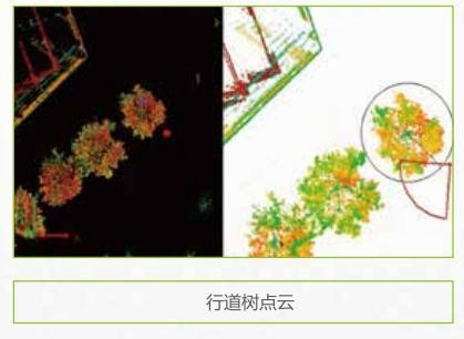
4. Urban landscaping survey
Quickly collect the 3D point cloud data of garden trees on both
sides of the road. Through the garden survey software, the
geometric information such as tree position, diameter, tree height
and crown width can be extracted semi automatically. At the same
time, combined with the panoramic image, the tree information can
be extracted.


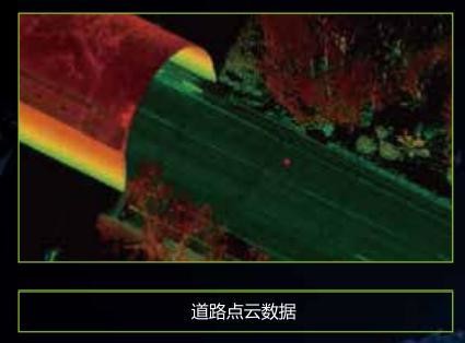
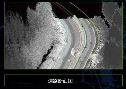
5. Highway survey and intelligent transportation
Collect 3D laser point clouds on the road and both sides in the
process of rapid movement, and can quickly produce road vertical
and horizontal sections, strip topographic maps and traffic
thematic spatial geographic information data.

6. Digital 3D city
Quickly scan and obtain urban basic data, directly obtain 3D
spatial point cloud data of the scene, corresponding
high-definition texture image and panoramic image, and quickly
obtain 3D data model through model data fusion technology.


